Hunts Creek Walks and Tracks
Latest News | August 2025
Hunts Creek Walking Track now open for nature walks and wildlife spotting.
Since late-May, sections of the Hunts Creek Walking Track were closed while Council’s Natural Areas and Civil & Infrastructure teams worked on upgrades to four (4) pedestrian bridges along the track.
The work focused on safety improvements and providing added protections to the foundations. The bridges’ support structures, which are subject to a high volume of fast-moving flood water during storms, were also strengthened.
The Hunts Creek Walking Track program included the removal of 1 tonne of debris from in and around the creek. Deteriorated decking planks, bearers and joists, were replaced with new hardwood timber and top rails were also replaced. Sixty (60) linear metres of hardwood decking was used in the project. That’s about the width of an NRL field, or a little bit more than our outdoor pool at PAC.
The use of hardwood and abutment works – to strengthen the bridges’ supports and protect them from future erosion – mean the new bridges have an anticipated life span of 30 years.
Image Gallery of Upgrade Works
Introduction
Hidden among the suburban landscapes of North Rocks and Carlingford, behind houses and roads, is Hunts Creek Reserve - a patch of nature that provides a sanctuary for wildlife and amenity to locals and visitors.
In the 1960s, when the area was being developed, Council and progressive residents realised the importance of local bushland and worked to protect Hunts Creek Reserve.
It is now highly valued by the local community as a place for recreation, a peaceful escape, and a connection with the natural world.
Close to Hunts Creek Reserve is Seville Reserve. It has a smaller catchment area and has suffered less disturbance, and its bushland is generally in better condition.
For many bush plants and animals the reserves are home, and are vital for their survival. So far we have identified about 250 native plant species and 52 native birds, reptiles, amphibians and mammals that live in or visit the reserves.
Without ongoing care and management wildlife within the reserves face an uncertain future of weed infestation, plant and animal extinction, and water pollution.
Today the reserves form a vital part of the Lake Parramatta Hunts Creek corridor. These natural areas provide essential habitat for an array of native wildlife species across the Parramatta River Catchment. Please help to protect these values by following the reserve’s user regulations.
Vegetation
As you walk within Hunt Creek Reserve, you will pass through three distinct vegetation communities.
Coastal Enriched Sandstone Moist Forest is located closer to the creek. Sections of Sydney Turpentine–Ironbark Forest and Coastal Enriched Sandstone Dry Forest occupy sections of the reserve as you move up the catchment and away from the creek.
History
Hunts Creek is thought to have been used by First Nations communities including the Dharug, Burramattagal, Bidjigal, Terramerragal and Wallumattagal.
European settlers described Hunts Creek as the cleanest waters of the area and used the water to make peach cider (which was illegal at the time).
Bushranger Jack Donohue and his gang fled to the caves of Hunts Creek during the 1820s. They may have relied on the knowledge and lifestyles of Australia’s first peoples to survive.
In 1876, Captain James Burns, commander of the Parramatta Troop of the NSW Cavalry took over 200 acres of land to build Gowan Brae, an extravagant Victorian home. The estate included 30 acres set aside for tennis lawns, terraces and an artificial lake. Twenty acres were planted as an orchard with 20 to 30 fruit varieties.
Burns was also a renowned businessman and philanthropist, owner and co-founder of the Burns Philp Shipping Line. Burns also built several Burnside Presbyterian Orphan Homes. On his death in 1923, Gowan Brae was donated to the Burnside Presbyterian Orphans Homes.
In 1955, Gowan Brae became The Kings School until the school relocated in 1964.
In the early 2000s the Heritage Office of NSW moved into the main building and master's cottage of Gowan Brae.
The Sydney headquarters of Burns Philp & Company can be seen today. The impressive sandstone building stands at 7 Bridge Street, Sydney, reflecting James Burns’ opulent tastes.
Walking Track Map
There are a number of walking tracks in Hunts Creek Reserve.
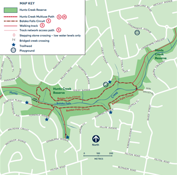
Balaka Falls Circuit
Grade 3 – 1800m loop / 1 hr
The Balaka Falls Circuit is a 1.8km Grade 3 loop which takes around one hour and provides you with a major scenic highlight, Balaka Falls, in the central location of Hunts Creek Reserve.
From the falls, or several other entry points, you can enjoy a scenic loop walk around Hunts Creek taking in a variety of forest types that unfold along the way.
While the western creek crossing along the circuit may be impassable after rain, the eastern crossing (near Sun Valley Place entrance) on the loop is bridged and can be used in most conditions outside of flood events.
Balaka Falls Circuit forms an integral part of the trail corridor running along Hunts Creek offering ready access from Parkland Road down to Bettington Road. There are no public creekside trail connections down to Lake Parramatta.
 Multi-use Path
Grade 2 – 600m one way / 15 min
This 600m multi-use Grade 2 path along Hunts Creek runs from Bettington Road Trailhead northeast across to Northam Drive. It takes around 15 minutes to complete. The path is surfaced and bridged creek crossings allow for access in most conditions.
Travelling further east beyond Northam Drive you can follow a Grade 3 walking track, the Balaka Falls Circuit, up along Hunts Creek.
Along the way if creek levels are low, you can cross the creek and visit Balaka Falls.
To the west of the Hunts Creek Multi-use Path, a short level walking track leads down along Hunts Creek to the boundary of The Kings School. Please note there are no public creekside trail connections down to Lake Parramatta.
Download the Hunts Creek Multi-use Path or view it below.
Download the Maps
Regulations and Cautions
Please be aware that creek crossings may be impassable during and after light to heavy rain events.
Do not use Balaka Falls Circuit when water is flowing over stepping stones at creek crossings.
Dogs are to be kept on leads at all times and cats are not allowed in the reserve at all.
No bicycles are allowed on walking tracks. Bicycles are permitted on the Hunts Creek Multiuse Path of the reserve. Swimming is not advised in any areas of the reserve.
More Information
For more information, contact Council’s Natural Areas team at naturalresources@cityofparramatta.nsw.gov.au or call Council’s Customer Service Centre on 1300 617 058.
Related Links