Western Sydney Flood Resilience Program
Hill Road as we all know, is our main road into Wentworth Point and our main way out. It is also one of the main sources of frustration for many in our community.
Flooding is a safety risk, and flooding often results in closure of Hill Road. Road closures with few alternative routes cause great distress for the community including residents and drivers of the 2,200 vehicles that travel along the 4km road each hour during peak times.
For many years, City of Parramatta has advocated on behalf of residents in Wentworth Point and the Carter Street Precinct for additional resources to better manage flooding in this area.
With $50M in funding now provided by the NSW Government under the Western Sydney Resilience Program, Council will begin a long-term project to manage flooding to reduce flood risk and minimise disruption to the community.
The flood work will be supported by $8.5M in funding from the Australian Government for upgrades to Hill Road, including improved lighting, and intersection treatments that address current safety concerns.
Latest news
Latest news – May 2025
Work begins with the appointment of specialist consultants
Late last year, the City of Parramatta was awarded $58.5M from the Australian and NSW Governments to address flooding on Hill Road in Wentworth Point and in surrounding neighbourhoods.
With the recent appointment of consultancy Haskoning Australia Pty Ltd, the 12-month program is now underway (construction follows as a separate project).
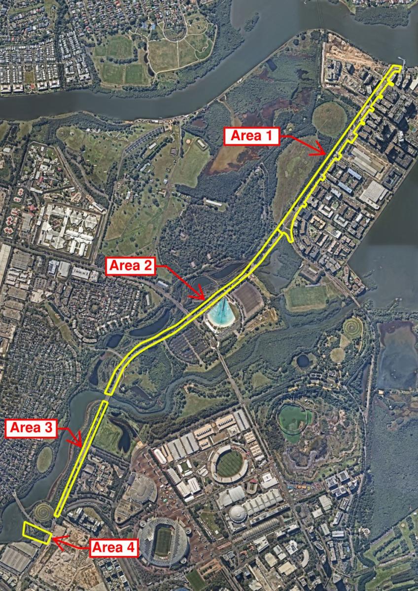
Improving flood resilience in the area will be complex and challenging. A multi-disciplinary team has begun work which will focus on four key areas:
- Hill Road between Bennelong Parkway to the Parramatta River
- Hill Road Between Bennelong Parkway and Haslams Creek Bridge
- Hill Road from Haslams Creek Bridge to Fantail Street
- Creating an overland flow path near Carter Street off Hill Road.
What happens now? Flood studies, flood model and investigations
Later this month, specialists will begin preliminary studies including topographic and aboricultural surveys, traffic studies, capturing data from historical flood markers, and undertaking ecological investigations.
This information will be used in the development of a new flood model to define the existing flood characteristics in Wentworth Point area and in the wider Haslams Creek catchment area north of the M4.
The flood model will be used to test the performance of potential drainage design options which will look to improve the existing flooding problem along the four specific lengths of Hill Road.
The draft flood study, including a flood model, will be on public exhibition in late 2025. The flood study is planned for completion in early 2026*.
Floodplain Risk Management Study and Plan
Following the refinement of the flood model, work begins on a Floodplain Risk Management Study and Plan. This work responds to the findings of the flood model and investigates potential solutions to flooding in the area. Options for mitigation works are detailed with recommendations made.
The Flood Risk Management Study and Plan will consider longer term planning measures that can be implemented to assist in reducing the impact of flooding. This work will also support the development of the Wentworth Point, Newington and Olympic Park precincts, and emergency response measures that will manage flooding that cannot be mitigated.
Opportunities to improve the amenity of the precinct will also be explored. Urban design upgrades will include water sensitive measures.
The draft Floodplain Risk Management Study and Plan will be on public exhibition in 2026*.
Civil and drainage design options
The final stage of the project is developing civil and drainage design options and undertaking street improvements such as upgrades to lighting and tree planting.
Civil and drainage design options will be evaluated before a preferred concept design is progressed.
Potential designs to help minimise flooding on Hill Road could include:
- Nature-based solutions where elements such as wetland channels could be introduced to the area
- Engineered solutions which might use stormwater pipes and culverts.
Initial civil and drainage designs will be on public exhibition in 2026*.
The construction of improvement works, potentially civil works and drainage design solutions and/or nature-based flood mitigation works, is not expected to take place until 2028.
See the project examples tab for some of the design elements that may be incorporated into the solution for Hill Road. Designs to reduce the frequency of flooding on Hill Road will respond to the findings of the flood studies and flood modelling.
We will keep the community updated on opportunities to have a say and timeframes as the project progresses.
* Timing subject to change.
What are the challenges of Hill Road?
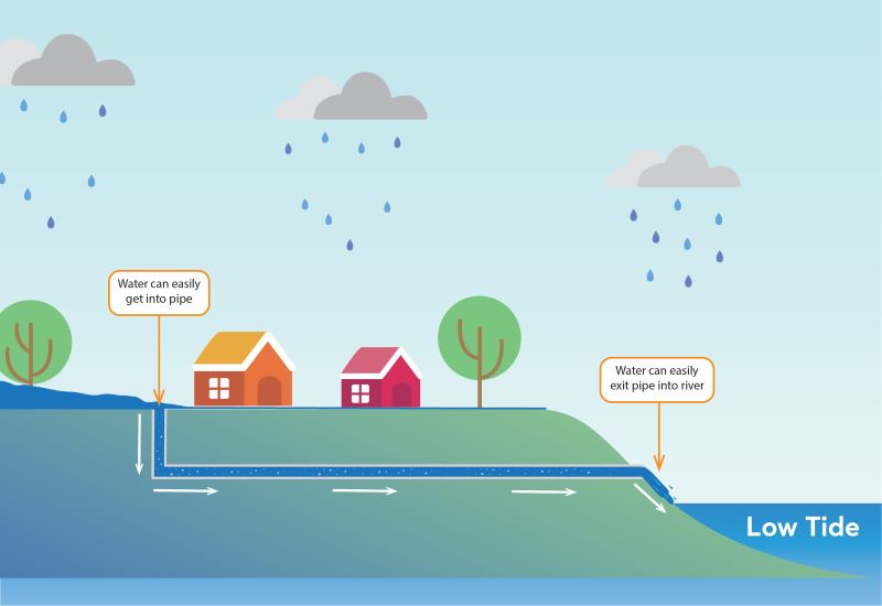
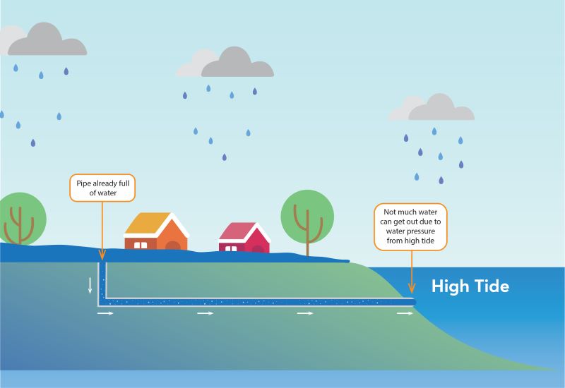
There are a number of issues which contribute to flooding on Hill Road including the gradient of the road, numerous pieces of stormwater infrastructure which all drain to Hill Road, and tidal action.
Additionally, the project must take into consideration existing constraints that include the Olympic Park Precinct, sensitive environmental areas, and approved development.
Separately, State Significant Infrastructure projects are planned with enabling works and investigations to support future construction works in progress. These include:
a) Advanced treated water transfer line to Parramatta River (Sydney Water)
b) Stage 2 of the Parramatta Light Rail (Transport for NSW)
c) Hill Road intersection upgrades at the southern end of Hill Road near the M4 (Transport for NSW).
The Hill Road drainage improvement works will be coordinated with existing and future constraints, liaising with NSW Government agencies, to deliver the most appropriate design solution.
The projects below provide examples of how flooding has been managed in other areas across Sydney and internationally. However, these are not the solutions for the Hill Road project.
Once studies are completed and design options considered, flood mitigation elements like these may be introduced to Hill Road to help reduce the frequency of flooding in the area.
-
This Sydney Water stormwater culvert project near Botany was designed to address a 10% (Annual Exceedance Probability (AEP) flood event.
AEP is the chance that a flood of a particular size will happen in any one year.
The civil and structural design featured large twin pipes, the installation of eight (8) large pits, and large Gross Pollutant Traps (stormwater installations which capture litter before it can enter our waterways).
The project also included the construction of a 2.5ha wetland which acts as a water filter, improves water quality, and provides important freshwater wetland habitat. (Pictured below).
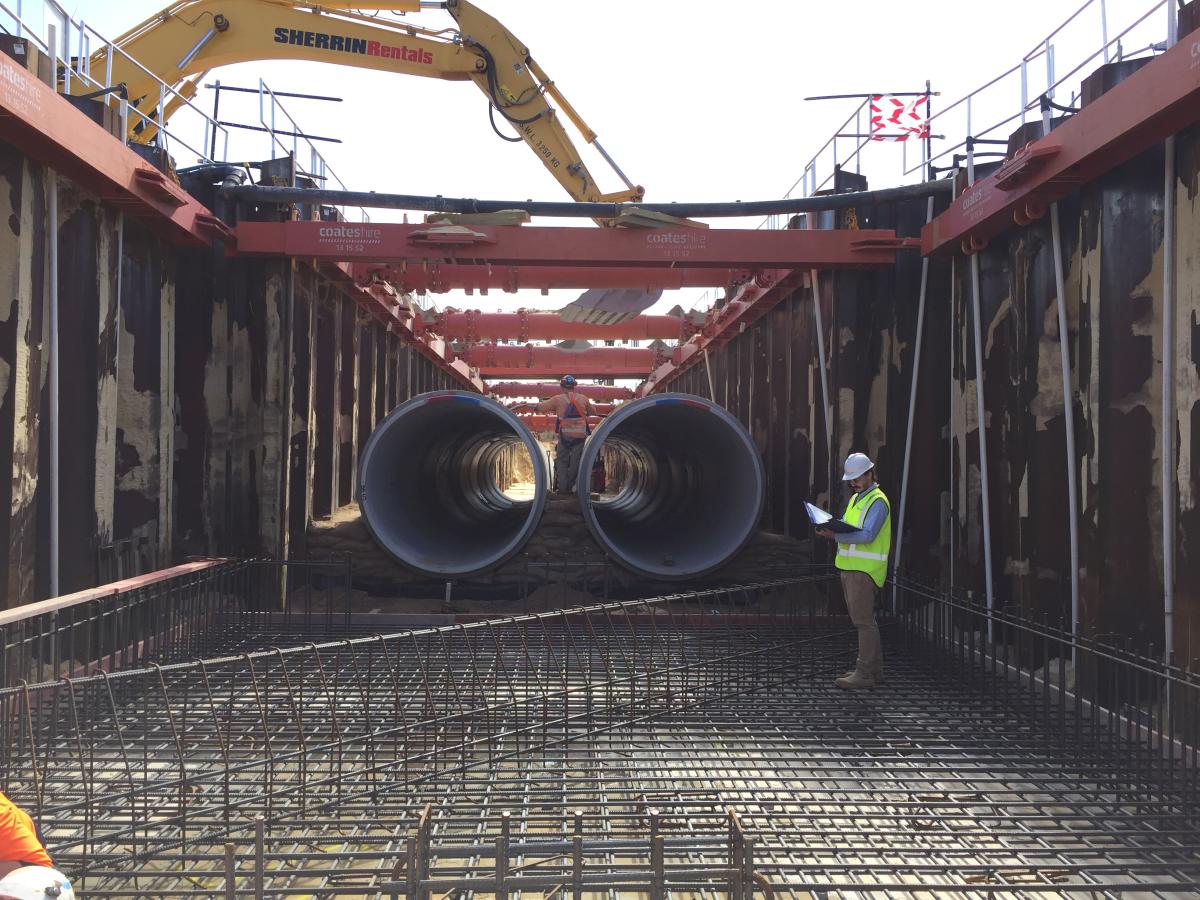
The civil and structural design solution for Astrolabe Park, used oversized twin pipes designed to address a 10% AEP flood event, and the installation of eight (8) large pits, and large Gross Pollutant Traps. This solution addresses a very large flood area. Pipes of this size would not be introduced as part of the Hill Road Project. -
This bank restoration project relied on a nature-based solution to restore a historic stormwater channel and mitigate against a 10% Annual Exceedance Probability (AEP) flood event.
AEP is the chance that a flood of a particular size will happen in any one year.
Cracked and deteriorated concrete walls lining the creek bank were causing erosion and were replaced with sloped sandstone walls.
While the channel was widened, newly created embankments allowed for the planting of saltmarsh and native vegetation. The naturalisation of the channel introduced new wildlife habitats.
A public space was created along Powells Creek with shared paths, boardwalks and seating installed to encourage the community to enjoy the new wetland areas. (Pictured below).
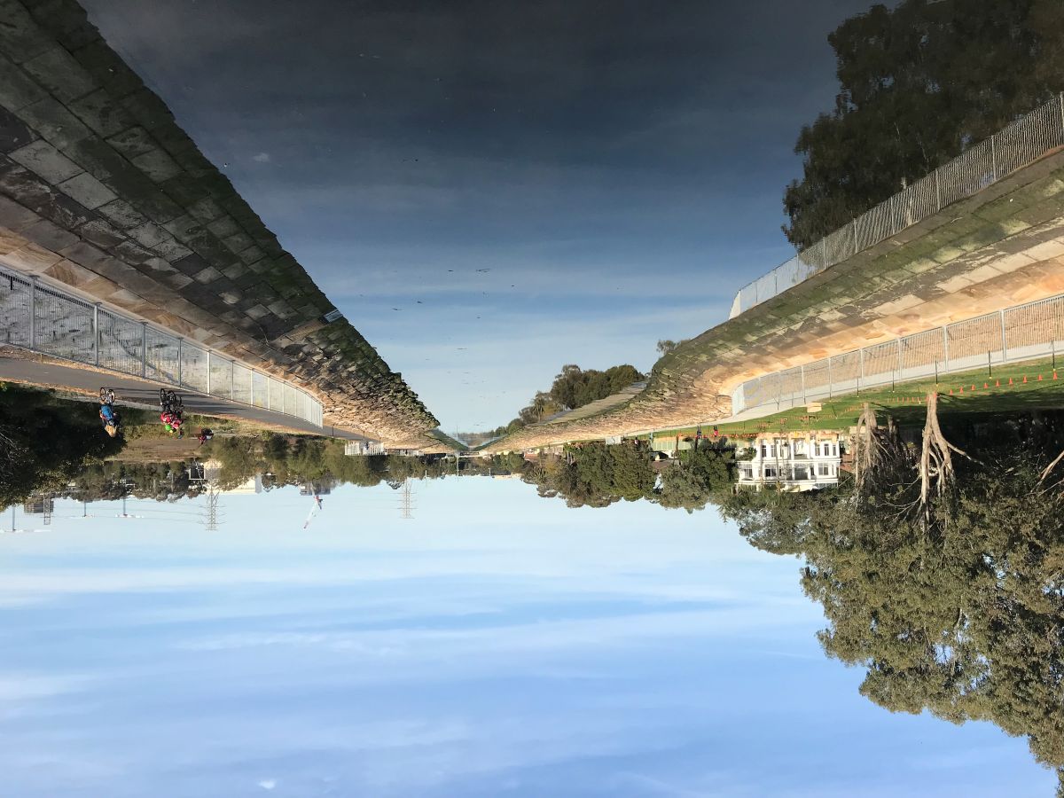
In Powells Creek, a nature-based solution was developed to restore a historic stormwater channel and mitigate against a 10% AEP flood event. -
The rehabilitation and naturalisation of Johnstons Creek at Rozelle Bay took a nature-based approach to the replacement of the concrete channel base lining the creek.
The project preserved heritage sandstone by using a combination of new concrete and sandstone blocks on the base (or floor) of the open channel creek. Along with stabilisation of the walls with sandstone blocks, the design introduced planted creek banks, rock pools and marshes along both sides of the creek.
The project included seating, interpretative signage and a new footbridge which provided the community with the opportunity to engage with the revitalised channel. The works also included vegetated swales which treat run-off from the adjoining residential and road catchments prior to the water entering the Johnstons Creek channel.
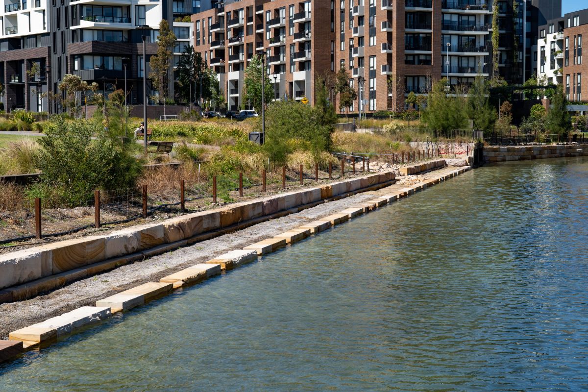
The rehabilitation and naturalisation of Johnstons Creek took a nature-based approach to the replacement of the concrete channel base lining the creek. Concrete and sandstone blocks were introduced along with planted banks and rock pools.
-
Drainage works in Mona Vale were developed to reduce frequent flooding in a commercial precinct. Properties have a floor level below the top of the kerb and experienced flooding approximately once every two years.
The design solution involved the combination of an upgrade to the trunk (main) drainage works, to divert some of the stormwater run-off, as well as the development of a concrete planter box to divert run-off away from the properties.
The planter box also included seating to improve the amenity of the local area. Overall, the stormwater works improved the area’s flood immunity to 10% AEP. (A 10% chance of a flood happening in any one year).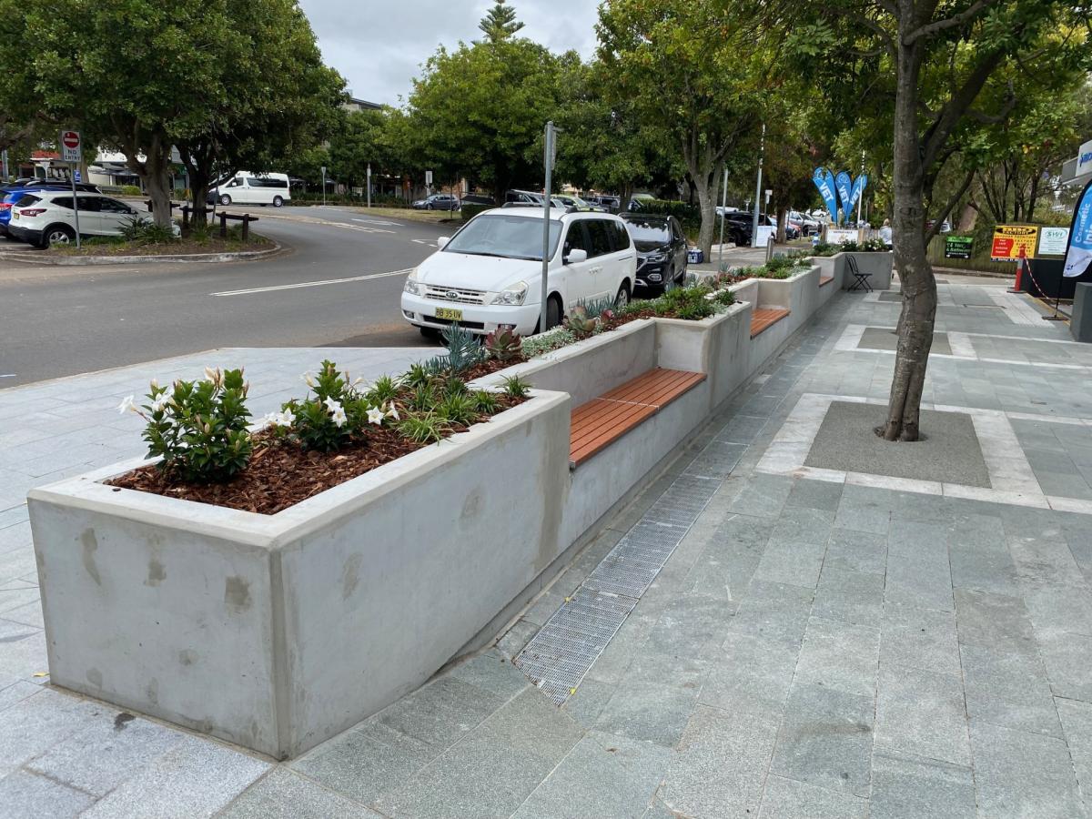
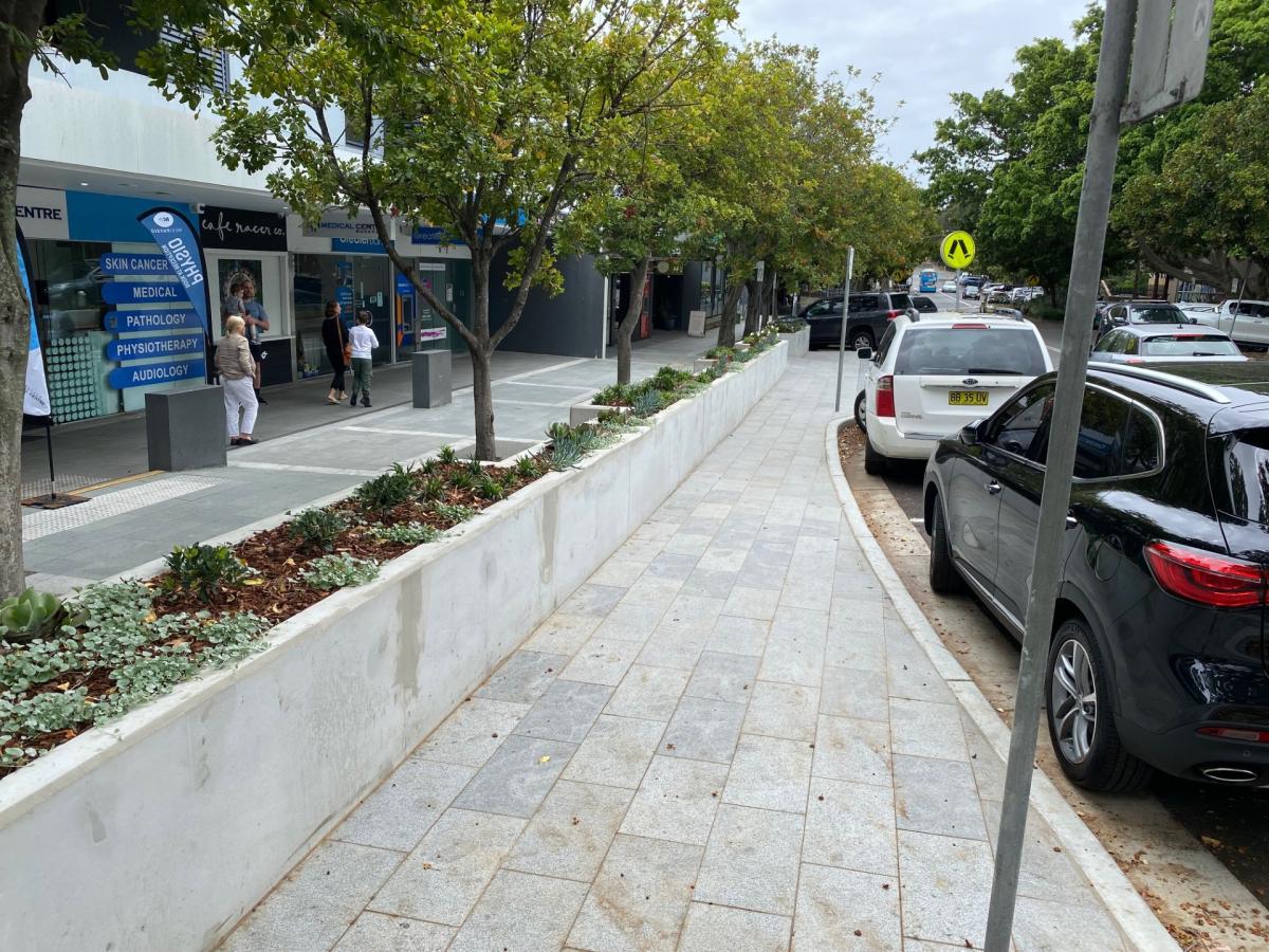
Properties in a commercial precinct in Mona Vale, with a floor level below the top of the kerb, experienced flooding approximately once every two years. Drainage upgrades and the installation of a planter box helped to divert stormwater run-off and reduce the frequency of flooding. -
The stabilisation of an existing watercourse required a design which would maximise the retention of native vegetation.
In the final design, vegetation was supported by sandstone blockwork and rocks to provide protection against high velocity stormwater.
The project also improved stormwater quality through a bio-retention basin (planting) to collect and treat run-off from the adjoining roadway. A bio-retention basin can be used within a parkland area, or where space permits, can be shaped in the form of a roadside channel that collects and treats run-off from the road catchment.
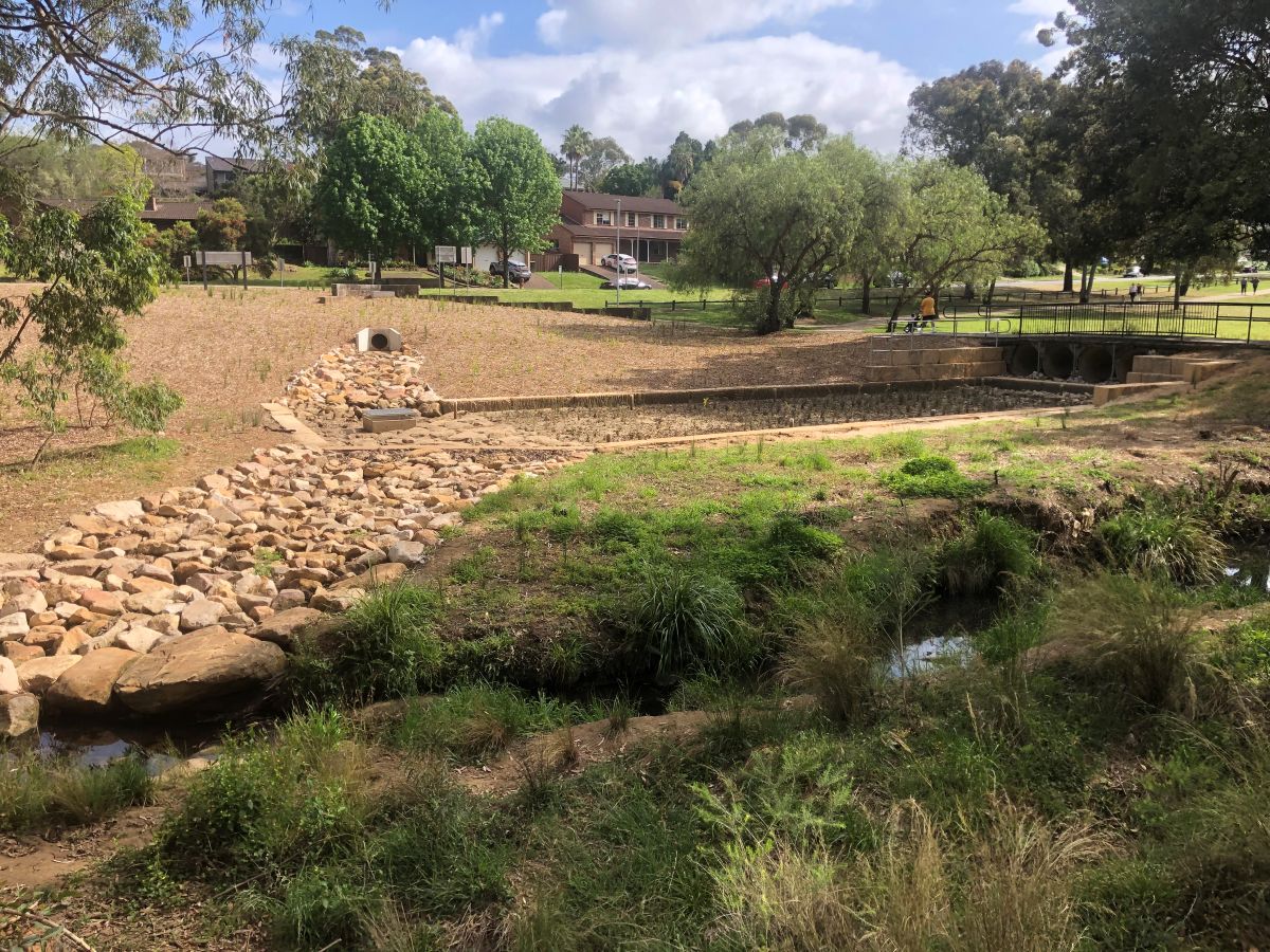
The design solution to stabilise an existing watercourse and maximise the retention of native vegetation, saw the creation of a bio-retention basin to improve water quality, and the installation of sandstone blockwork and rocks to provide protection against high velocity stormwater. -
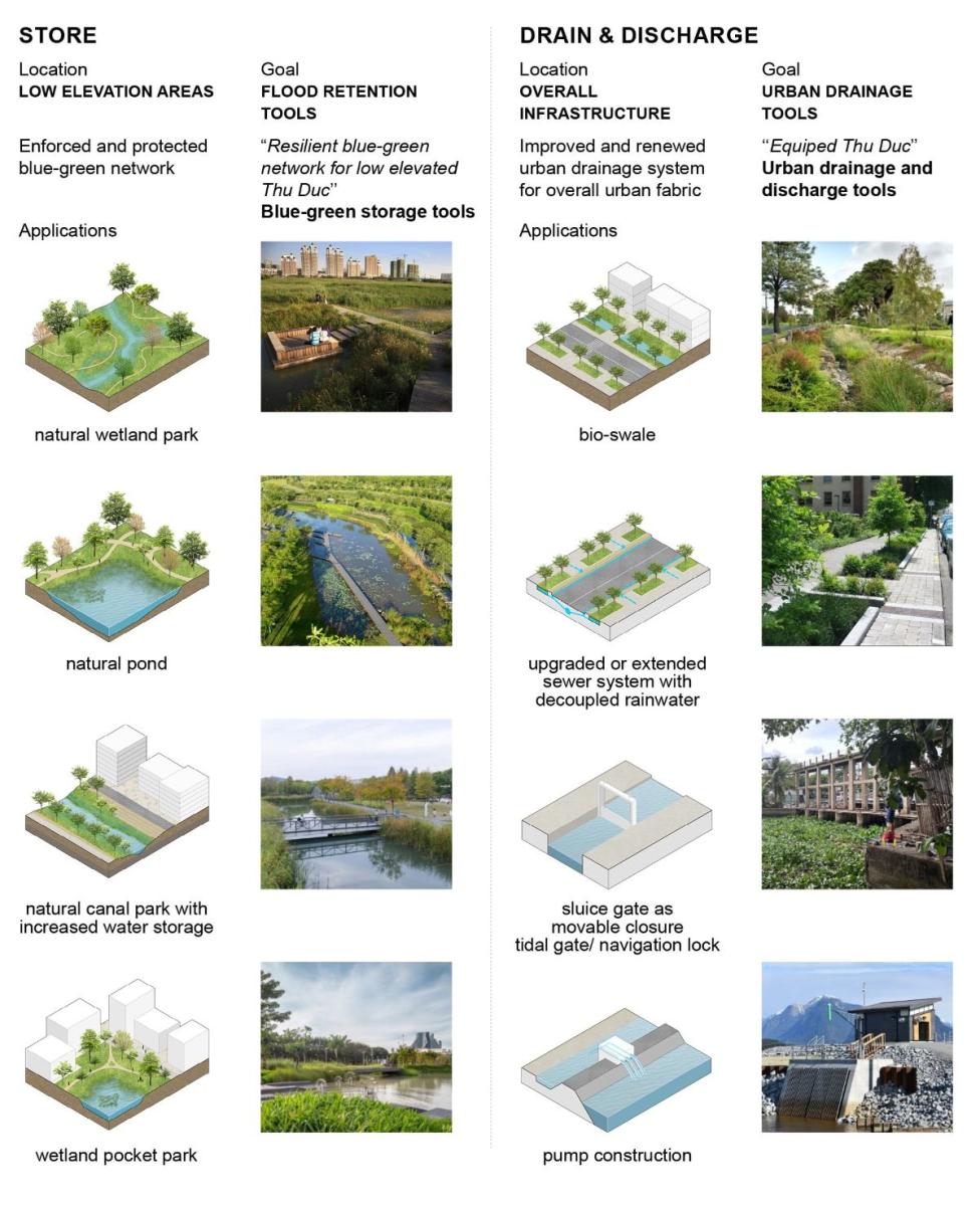
Located in Ho Chi Minh, Vietnam, this project focused on developing a comprehensive flood risk management strategy.
The work included developing designs for water storage, including wetland and pond designs, as well as drainage upgrades and discharge designs incorporating bio-swales.
The project focussed on a rapid assessment of the city to identify flood-prone areas, develop strategic recommendations for future flood adaptation, and create intervention options with a focus on nature-based solutions.
The roadmap created for effective flood risk management, prioritised low-cost designs delivering significant benefits in the short term, which also aligned with the long-term flood adaptation process.
-
While improving drainage and reducing flood impact is the key focus of this project, the solution will not be simple or quick.
Expected to take around three years, the scope of the project will include technical investigations and then design and construction of a major drainage system to capture and divert large flows and reduce the depth of water on the road.
City of Parramatta will keep the community informed as the project progresses and highlight points within the program where there will be opportunities to provide feedback on draft design concepts.
For more information
Please see the Hill Road Upgrade Western Sydney Flood Resilience Program, brochures available in English, Korean and Simplified Chinese.
-
There are many contributing factors to flooding on Hill Road including the gradient of the road (Hill Road is as little as 0.2% grade and is actually very flat) and the number of roads and dwellings which drain to Hill Road.
High tides also play a part in reducing the amount of stormwater that can be discharged into the Parramatta River. In high tide, with the drainage outlet covered by the Parramatta River, water cannot easily drain to the river. Water banks up in the drain and pools at the drain inlet.
For more information on this project
Call: 1300 617 058
Email: hillrd@cityofparramatta.nsw.gov.au

The $58.5million Hill Road flood resilience project and safety improvement project is proudly funded by the Australian and NSW Governments in association with City of Parramatta Council.