Know your flood risk
(Back to top)FloodSmart Parramatta now provides flood risk information for the Upper Parramatta River which includes the upstream areas from Parramatta CBD. This will allow you to understand if your property is at risk of flooding and how frequent or significant floods could be.
In mid-2024, four new areas will be made searchable as new data becomes available for A’Becketts Creek, Duck River/Creek, Haslams Creek, Terrys Creek.
Other areas will be made searchable as new data becomes available. If you live outside of this area you can check your properties section 10.7 certificate or apply for a Flood enquiry application (charges may apply).
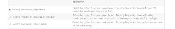
Making a Flood enquiry application
Once on the page, click on the downward arrow on the Development tab.
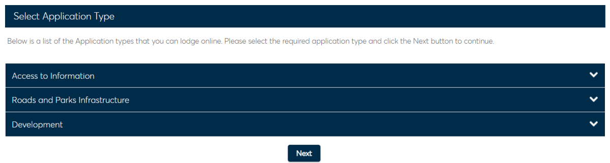
In the Development menu, click on the flooding enquiry appropriate for your situation.
Check if your home or business is in a flood prone area
(Back to top)Enter your address below to find out if your home or business is at risk of flooding.
Click on the map next to your property to view the full information.
Flood risk areas explained
(Back to top)| Risk area | Common description | Technical description |
|---|---|---|
| High risk area |
|
High hazard flood area within the 1% annual exceedance probability (AEP) (1:100) |
| Medium risk area |
|
Medium and low hazard area in the 1% AEP (1:100) |
| Low risk area |
|
Area from the 1% AEP (1:100) up to the Probable Maximum Flood |
|
Everywhere else |
Not expected to flood but there still could be local incidents water running off the land and of street drainage not coping with rainfall amounts. |
Area outside the Probable Maximum Flood. There may still be isolated impacts from local overland flow. |
Don't forget, even if your property is not in the high, medium or low risk areas you may still see the impact of floods in your area. These could include:
- deep and fast flowing rivers and creeks
- closed roads or bridges
- impacts on travel routes
- submerged fields or parks
- flooding to other homes, schools or businesses.
- This mapping is not intended for development or planning use and will not be accepted by Council as evidence to influence a development application.
For detailed flood information, required by Council for planning and development applications, please submit a Flood enquiry application.
- This mapping provided above shows the current best estimation of flood risk using existing officially adopted City of Parramatta flood model data.
- The data provided is already available to the public through the floodplain development process and has not been created specifically for this project.
- Risk areas shown are for educational purposes only and should be used by residents and businesses to determine if an emergency plan is needed.
- The mapping is not intended to accurately represent impacts on the ground during a flood for emergency response purposes.
- Every flood is different please make sure that you prepare for every eventuality.