On this page you will find details and information on the facilities, history and vegetation of Third Settlement Reserve.
Third Settlement Reserve is located at:
3 Edison Parade, Winston Hills NSW 2153
20 Edison Parade, Winston Hills NSW 2153
Facilities
(Back to top)You can find the following list of facilities at the reserve:
|
Public Toilets x 2 |
Drinking taps |
|
Playground |
Outdoor Exercise equipment |
|
Basket Ball Court full sized |
Netball Courts full sized x 2 |
|
Scout Hall |
Girl Guides Hall |
|
Electric BBQ |
Covered seating |
|
Concrete walking track |
Bushwalking track |
History
(Back to top)Within the homelands of the Toogagal (or Tugagal) clan of the Darug nation, Third Settlement Reserve is on the north bank of a gently sloping valley which reaches up to a crest, that looks all the way to Colomatta (Blue Mountains). Australias’ first nations people would have travelled from the open marsh lands to the west into the gentle valley. They would have names and stories of the fork of stream where Bogalara Creek meets Toongabbie Creek in the west and where Quarry Branch Creek meets Toongabbie Creek, just like we now have names and stories of every street and local shop. A rich diversity of food and resources would have been available due to the meshing of two distinct landscapes that transition into the gentle valley that now separates Northmead from Winston Hills.
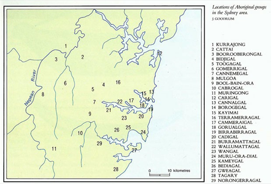
The location of the Toogagal clan within the Sydney basin is illustrated on the following map.
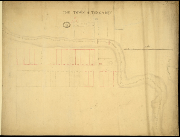
In 1792 the Colonists, governed by Captain Arthur Phillip set up a farming area to address a food shortage, accommodate the growing troop numbers and manage convicts outside of Sydney Cove and Parramatta. The Third Settlement was born and the area was named Tongabby, based upon the Aboriginal word for the area said to mean ‘meeting of the waters’ referring to the nearby confluence of Toongabbie and Quarry Branch Creeks.
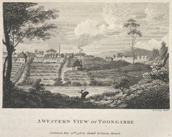
Images below show 'The Town of Tongabby' and 'A Western View of Toongabbe'.
The settlement grew and area was named Model Farms. The small township evolved just west of Bogalara Creek until 1860. At that time the new Parramatta to Blacktown railway was constructed and the newly named Toongabbie township was formed 2km to the west, thus allowing Third Settlement Reserve to remain undeveloped.
Farming continued over the reserve until the 1960s when Winston Hills (previously known as ‘Model Farms’) started to be subdivided for residential development that confined the open space to the slender parcel along the creek. Many of the nearby street names reflect famous writers, scientists, Greek gods and biblical figures. The surrounding area was transferred to Parramatta from Blacktown in 1972, with Third Settlement Reserve being officially gazetted in 1988.
Third Settlement Reserve contains mainly the Sydney Coastal River Flat Forest vegetation community that would have been surrounded by Cumberland Shale Plain and Cumberland Shale Hills Forest. The Cumberland Shale Forests transitions to Sydney Turpentine Ironbark Forest towards the east, which are all listed Threatened Ecological Community The current official listing of Sydney Coastal River Flat Forest is River-Flat Eucalypt Forest on Coastal Floodplains of the NSW North Coast, Sydney Basin and South East Corner bioregions under the Biodiversity Conservation Act 2016 (NSW) and Environment Protection and Biodiversity Conservation Act 1999 (Commonwealth)
The composition of the River-Flat Forest is primarily determined by the frequency and duration of waterlogging and the texture, nutrient and moisture content of the soil. The Third Settlement vegetation community is characterised by the following assemblage of species:
|
Acacia decurrens |
Eucalyptus tereticornis |
|
Acacia implexa |
Gahnia aspera |
|
Angophora floribunda |
Glycine microphylla |
|
Breynia oblongifolia |
Juncus usitatus |
|
Casuarina glauca |
Melaleuca decora |
|
Cayratia clematidea |
Notelaea longifolia |
|
Commelina cyanea |
Pittosporum undulatum |
|
Cyperus laevis |
Polyscias sambucifolia |
|
Dianella longifolia |
Sigesbeckia orientalis |
|
Einadia trigonos |
Trema tomentosa |
|
Eucalyptus saligna |
|
Images taken with thanks from
The Town of Tongabby: National Archives UK CO_700_NEWSOUTHWALES5_1792
A Western View of Toongabbe: Courtesy of the State Library of NSW, location: Facsimile edition at REF 1/991/89-90, digital order number: a1341009